Exploring the Hochschwab Straße – Lawinenschutztunnel Hesslahn: A Motorcyclist’s Guide
Locals know best!
If you travel this road often or live close by you will be given a chance to provide your valuable rating soon! Sign in and stay connected.Location and Setting of the Hochschwab Straße – Lawinenschutztunnel Hesslahn
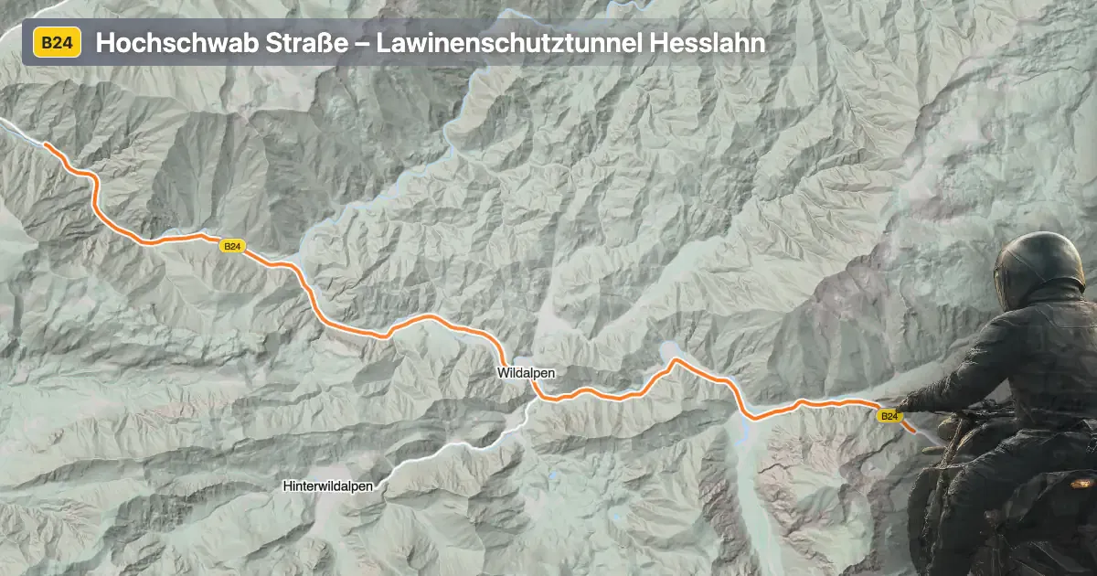
The Hochschwab Straße – Lawinenschutztunnel Hesslahn is located in the Austrian state of Styria, traversing the northern foothills of the Hochschwab mountain group. The road runs parallel to the Salza River, a tributary of the Enns, and passes through the Rauchmäuergraben valley. The route is set amidst the Hochschwab-Gruppe, with the Ybbstaler Alpen and Kräuterin mountain ranges nearby, providing a backdrop of alpine landscapes. The road’s proximity to these ranges makes it a point of interest for those seeking to experience the natural beauty of the Austrian Alps. An interactive map showing the precise route of the Hochschwab Straße – Lawinenschutztunnel Hesslahn can be found at the end of this article.
Loading road width, lane configuration, and surface quality dataOpen Map Explorer for More Road DetailsRoad Characteristics and Riding Experience
The Hochschwab Straße – Lawinenschutztunnel Hesslahn extends for approximately 21 km (13 miles), with the majority of its length offering a wide, two-lane asphalt surface. The road is gently curved, making it accessible for riders of varying skill levels. Surface quality is generally very good, providing a comfortable ride. The route passes through both inhabited and uninhabited areas, with about one-fifth of the road running through settlements. Elevations range from 521 m (1,709 ft) to 671 m (2,201 ft), ensuring moderate altitude changes without steep gradients. The road follows the Salza River for its entire length, offering continuous views of the waterway and the surrounding alpine terrain. Speed limits vary along the route, with sections posted at 50 km/h (31 mph), 80 km/h (50 mph), and 100 km/h (62 mph), depending on proximity to settlements and road conditions.
Natural Features and Attractions Along the Route
One of the defining features of this road is its alignment with the Salza River, renowned for its clear waters and popularity among kayakers and rafters. The Hochschwab Straße also skirts the edge of the Ybbstaler Alpen and crosses the Kräuterin, providing access to hiking trails and alpine viewpoints. The region is part of the larger Alps, and the Hochschwab-Gruppe is particularly known for its rugged limestone peaks. Motorcyclists will find several viewpoints along the route, offering opportunities to stop and appreciate the landscape. The area is less frequented by mass tourism, making it an appealing option for riders seeking a quieter alpine experience. For those interested in exploring further, the nearby Salza River is a highlight, as is the broader Hochschwab region, which is home to diverse flora and fauna.
Road Closures, Seasonal Access, and Practical Considerations
The Hochschwab Straße – Lawinenschutztunnel Hesslahn is generally open to motorcycles throughout the year. However, due to its alpine location, temporary closures can occur during periods of heavy snowfall or avalanche risk, particularly in winter months. The Lawinenschutztunnel (avalanche protection tunnel) is a key feature designed to mitigate such risks, but riders should always check local traffic reports before planning a trip. There are no permanent restrictions on motorcycle access. Event-related closures are rare but may occur during maintenance or local events. For up-to-date information on road conditions and closures, the ASFINAG Traffic Reports website is a reliable resource.
Tolls, Fees, and Additional Information
Currently, there are no tolls or entrance fees specifically for using the Hochschwab Straße – Lawinenschutztunnel Hesslahn. However, toll conditions in Austria may change, and riders are advised to verify the latest information before traveling. For general information on road tolls and vignettes in Austria, consult the ASFINAG Toll and Vignette page. This resource provides details on national toll requirements, including for motorcycles and other vehicles.
| ROAD SCORE | ROAD ARTICLE |
|---|---|
4.8 | Exploring the Salzatal – Prescenylahn Route: A Motorcyclist’s Guide Through Austria’s Alpine Valleys |
4.2 | Exploring the Radstatthöhe Pass: B 25 Erlauftal Straße in Austria |
5.3 | Riding the Seebergsattel Pass: Exploring the B 20 Mariazeller Straße in Austria |
| ROAD SCORE | ROAD ARTICLE |
|---|---|
4.6 | Katschberg Pass (Katschbergpass) - B99: A Technical Overview for Motorcyclists |
8.6 | Exploring the Nockalm Road (Nockalmstraße): A Premier Alpine Motorcycle Route in Austria |
1 | Arlberg Pass (Arlbergpass) - B197: A Technical Overview for Motorcyclists |