Exploring the Leithagebirge Crossing: Eisenstadt’s Mountain Route for Motorcyclists
Locals know best!
If you travel this road often or live close by you will be given a chance to provide your valuable rating soon! Sign in and stay connected.Location and Geographic Context
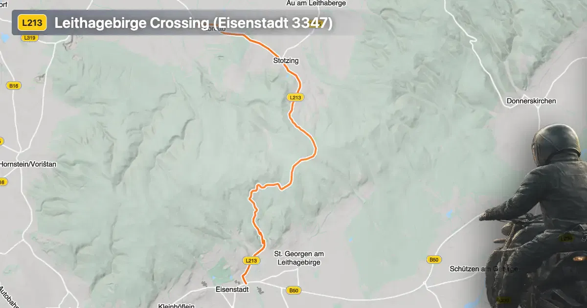
The Eisenstadt 3347 route is situated in eastern Austria, within the state of Burgenland. The road begins and ends in the town of Eisenstadt, the regional capital, and crosses the Leithagebirge, a low mountain range that forms a natural border between Burgenland and Lower Austria. The route passes through several local streets, including Leithabergstraße, Lorettostraße, Hauptstraße, Ingenieur-Hans-Sylvester-Straße, Eisenstädterstraße, Bürgerspitalgasse, and Europaplatz. The road’s alignment takes it through the Saubründlgraben and Auergraben valleys, offering a varied landscape of wooded hills and open countryside. An interactive map showing the Eisenstadt 3347 route can be found at the end of this article.
Loading road width, lane configuration, and surface quality dataOpen Map Explorer for More Road DetailsRoad Details and Riding Experience
The Eisenstadt 3347 covers a distance of approximately 12.7 km (7.9 miles), with elevations ranging from 163 m (535 ft) to 380 m (1,247 ft). The road surface is asphalt and is generally rated as excellent, providing a smooth and predictable riding experience. Most of the route (about 87%) consists of two lanes, with the remainder being single-lane sections. The road is predominantly wide (about 96%), allowing for comfortable maneuvering, even for larger motorcycles. The route is moderately curvy, offering a mix of gently curved and straight segments, making it suitable for riders of varying skill levels. About one-third of the road passes through inhabited areas, while the remainder traverses rural and forested landscapes. The Eisenstadt 3347 is not known for extreme twistiness, but its passage through the Leithagebirge and adjacent valleys adds interest for those seeking a relaxed yet engaging ride.
Natural Features and Points of Interest
The Eisenstadt 3347’s most distinctive feature is its crossing of the Leithagebirge mountain range. This low, forested ridge is notable for its limestone geology and forms a scenic backdrop to the route. The road also skirts the Saubründlgraben and Auergraben valleys, which are characterized by wooded slopes and seasonal streams. Eisenstadt itself is home to several attractions, including the Esterházy Palace, a baroque residence with extensive gardens, and the Haydn Church, where composer Joseph Haydn is buried. Riders may wish to explore these sites before or after their journey along the Eisenstadt 3347.
Speed Limits, Closures, and Practical Considerations
Speed limits along the Eisenstadt 3347 vary depending on the section, with posted limits of 30, 50, 70, and 100 km/h (19, 31, 43, and 62 mph). Riders should be attentive to local signage, especially when transitioning between inhabited and rural areas. There are no known seasonal closures affecting motorcycles on this route, and the road remains accessible throughout the year, barring temporary closures due to maintenance or local events. It is advisable to check for any event-related disruptions with the ASFINAG traffic reports before planning a ride.
Tolls, Fees, and Additional Information
The Eisenstadt 3347 does not currently require a toll or entrance fee for motorcycles. However, toll conditions may change in the future, and riders are encouraged to verify the latest information on the ASFINAG toll information website. The road’s excellent surface quality and lack of tolls make it an accessible option for both local and visiting motorcyclists.
| ROAD SCORE | ROAD ARTICLE |
|---|---|
4.2 | Exploring the Hochwolkersdorf–Stang Alpine Route: A Motorcyclist’s Guide |
4 | Exploring the Schwarzenbachbrücke Route through Naturpark Landseer Berge |
| ROAD SCORE | ROAD ARTICLE |
|---|---|
4.6 | Katschberg Pass (Katschbergpass) - B99: A Technical Overview for Motorcyclists |
6.7 | Staller Saddle (Staller Sattel / Passo di Stalle): A Technical Overview for Motorcyclists |
5.7 | Exploring the Dachstein Glacier Toll Road (Dachstein Gletscherstraße) by Motorcycle |