Silvretta High Alpine Road (Silvretta-Hochalpenstraße (Bielerhöhe)): A Premier Alpine Motorcycle Route in Austria
Locals know best!
If you travel this road often or live close by you will be given a chance to provide your valuable rating soon! Sign in and stay connected.Location and Overview of the Silvretta High Alpine Road
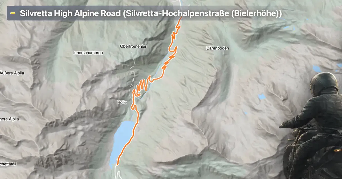
The Silvretta High Alpine Road (Silvretta-Hochalpenstraße (Bielerhöhe)) is situated in western Austria, traversing the border between the federal states of Vorarlberg and Tyrol. The route crosses the central Alps, connecting the Montafon valley with the Paznaun valley. The road is named after the Silvretta mountain group, which dominates the surrounding landscape. The route is easily accessible from both Bludenz and Landeck, making it a popular choice for riders touring the region. An interactive map showing the precise route of the Silvretta High Alpine Road can be found at the end of this article.
Loading road width, lane configuration, and surface quality dataOpen Map Explorer for More Road DetailsRoad Characteristics and Riding Experience
The Silvretta High Alpine Road extends for approximately 22.3 km (13.9 miles), with the majority of its length featuring a wide carriageway (about 95%), ensuring comfortable passage for motorcycles and other vehicles. The road is predominantly surfaced with high-quality asphalt, rated as excellent by most standards. Riders will encounter a very twisty alignment, with numerous hairpin bends and sweeping curves that demand attention and skill. The route climbs from a lowest elevation of 1,127 m (3,698 ft) to a highest point at 1,760 m (5,774 ft), offering significant elevation gain and panoramic views of the surrounding peaks. The maximum speed limit varies between 30 km/h (19 mph) and 60 km/h (37 mph), reflecting the technical nature of the road and the need for caution on its many bends. Only a small proportion of the route (about 22%) passes through inhabited areas, allowing for an immersive alpine riding experience. The road runs parallel to the Ill river for much of its length, providing additional visual interest and a sense of connection to the region’s natural features.
Seasonal Closures and Access Restrictions
The Silvretta High Alpine Road is subject to seasonal closures due to snow and adverse weather conditions. Typically, the road is closed to all traffic, including motorcycles, from late autumn through late spring. The exact opening and closing dates vary each year depending on weather and snow clearance operations. Riders are advised to check current road status before planning their journey, as unexpected closures can occur due to maintenance or special events. There are no regular event-related closures reported, but occasional cycling events or local festivities may temporarily restrict access. For up-to-date information on road openings and closures, consult the official Silvretta High Alpine Road website.
Tolls and Entrance Fees
Access to the Silvretta High Alpine Road requires payment of a toll, which applies to motorcycles as well as other vehicles. The toll is collected at designated points along the route, and the fee structure may change in the future. Riders should verify the current toll rates before their trip. Detailed and up-to-date information about tolls and entrance fees for Austrian roads can be found on the ASFINAG website, which provides comprehensive guidance for all road users in Austria.
Points of Interest and Attractions Along the Route
The Silvretta High Alpine Road is renowned for its proximity to several notable attractions. The route itself is considered a scenic highlight, offering multiple viewpoints where riders can pause to appreciate the dramatic alpine landscape. The road crosses the Silvretta mountain range, which is part of the greater Alps, a region celebrated for its geological and natural significance. The Ill river accompanies the road for much of its length, eventually flowing into the Rhine. Riders may wish to stop at the Bielerhöhe, the highest point of the route, which provides panoramic views and access to hiking trails. For further information about the Silvretta mountain range, visit Alps. Details about the Ill river can be found on Ill (Vorarlberg). The road itself is also featured on Silvretta-Hochalpenstraße. These resources provide additional context for riders interested in the natural and cultural history of the region.
| ROAD SCORE | ROAD ARTICLE |
|---|---|
1 | Arlberg Pass (Arlbergpass) - B197: A Technical Overview for Motorcyclists |
5.7 | Arlberg Pass Road: Riding from St. Anton am Arlberg to Stuben |
| ROAD SCORE | ROAD ARTICLE |
|---|---|
6 | Sölk Pass (Sölkpass (Erzherzog-Johann-Straße)): A Technical Overview for Motorcyclists |
3.4 | Kaunertal Glacier Road (Kaunertaler Gletscherstraße): A Technical Overview for Motorcyclists |
3 | Koppen Pass (Koppenpass): A Technical Overview for Motorcyclists |