Exploring the Brseč–Mošćenice Road: A Technical Overview for Motorcyclists
Locals know best!
If you travel this road often or live close by you will be given a chance to provide your valuable rating soon! Sign in and stay connected.Location and Access
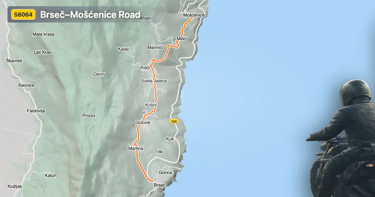
The Brseč–Mošćenice road is situated in the western part of Croatia, running along the eastern coastline of the Istrian peninsula. The route begins in the village of Brseč and concludes in Mošćenice, passing through the small settlement of Martina. The road is easily accessible from the main coastal highway and serves as a connector between these historic hilltop villages. Its proximity to the Adriatic Sea provides riders with frequent glimpses of the coastline. An interactive map showing the road’s precise route can be found at the end of this article.
Loading road width, lane configuration, and surface quality dataOpen Map Explorer for More Road DetailsRoad Characteristics and Riding Experience
This 7 km (4.3 miles) stretch of asphalt is characterized by a moderately twisty alignment, making it suitable for riders who appreciate a balance between technical turns and relaxed riding. The surface quality is excellent, with smooth asphalt throughout the route. Most of the road features a single lane (about 79%), with a small portion offering two lanes (about 5%). The width varies, with the majority being of medium or wide width (about 94%), allowing for comfortable passage even when encountering oncoming traffic. The elevation ranges from 156 m (512 ft) at its lowest point to 335 m (1,099 ft) at its highest, providing gentle climbs and descents. The posted speed limit is 60 km/h (37 mph), which is appropriate given the road’s curves and the presence of inhabited areas (approximately 40% of the route).
Viewpoints and Attractions Along the Route
The Brseč–Mošćenice road is notable for its series of viewpoints overlooking the Kvarner Gulf and the Adriatic coastline. These viewpoints offer opportunities to pause and take in expansive sea vistas, with several designated stops along the route. The villages at each end are themselves attractions: Brseč is known for its medieval architecture and cliffside setting, while Mošćenice is a well-preserved hilltop village with panoramic views and historical significance. Riders are encouraged to explore these settlements, as both offer a glimpse into the region’s cultural heritage. For more information on Brseč, visit its Wikipedia page, and for Mošćenice, see here.
Road Closures and Seasonal Considerations
There are currently no known restrictions or closures for motorcycles on the Brseč–Mošćenice road. The route remains open year-round, as the region’s mild coastal climate rarely results in winter closures. However, temporary closures may occur due to local events or maintenance work. Riders are advised to check local traffic updates before planning their journey, especially during the peak tourist season when increased traffic or events may affect accessibility.
Tolls, Fees, and Further Information
There is no toll or entrance fee required to ride the Brseč–Mošćenice road. The route is part of the public road network and is freely accessible to all vehicles, including motorcycles. Riders should be aware that toll conditions in Croatia may change, and it is advisable to consult official resources for the most current information. For details on road tolls and fees in Croatia, visit the Hrvatske autoceste toll rates page.
| ROAD SCORE | ROAD ARTICLE |
|---|---|
4.2 | Exploring the Cres–Porozina Road: A Motorcyclist’s Guide to the Island of Cres |
4.9 | Exploring the Labin–Mošćenička Draga Road: A Motorcyclist’s Guide |
| ROAD SCORE | ROAD ARTICLE |
|---|---|
8.7 | Riding the Poklon Pass: Exploring Županijska cesta 5047 through Učka Nature Park |
7 | Exploring the Rijeka–Gornje Jelenje Pass: A Motorcyclist’s Guide |
7 | Adriatic Route - Jadranska Magistrala - Velebit Coastal Route |