Exploring the Lepoglava–Zabok Route: A Technical Overview for Motorcyclists
Locals know best!
If you travel this road often or live close by you will be given a chance to provide your valuable rating soon! Sign in and stay connected.Location and Regional Context
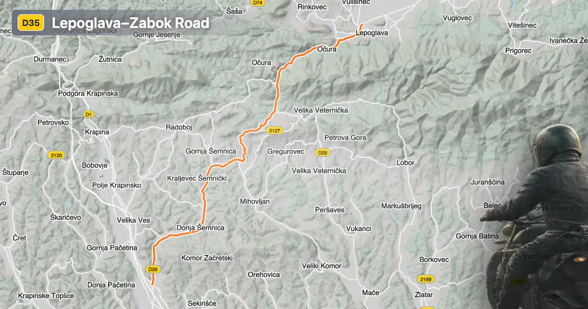
The Lepoglava–Zabok road is situated in the Hrvatsko Zagorje region of northern Croatia, connecting the towns of Lepoglava and Zabok. The route passes through settlements such as Zagorska ulica and Varaždinska ulica, serving as a key link between local communities. The road runs parallel to the Bednja River for a short segment, offering occasional views of the waterway as it makes its way toward the Drava River. The surrounding area is characterized by rolling hills and a mix of rural and urban landscapes. An interactive map showing the precise route of the Lepoglava–Zabok road can be found at the end of this article.
Loading road width, lane configuration, and surface quality dataOpen Map Explorer for More Road DetailsRoad Characteristics and Riding Experience
The Lepoglava–Zabok road extends for approximately 20.6 km (12.8 miles), with the majority of its length featuring wide, two-lane sections (about 90%). The surface is asphalt and is generally rated as very good, providing a smooth ride for most motorcycles. The road is moderately curvy, with gentle bends that allow for a relaxed pace rather than aggressive cornering. Elevation ranges from 158 m (518 ft) at its lowest point to 387 m (1,270 ft) at its highest, resulting in mild elevation changes suitable for riders of all experience levels. The route passes through inhabited areas for roughly 42% of its length, so riders should be mindful of local traffic and speed regulations. The maximum speed limits along the road vary between 30, 40, 50, and 60 km/h (19, 25, 31, and 37 mph), depending on the specific segment and proximity to settlements.
Points of Interest and Nearby Attractions
While the Lepoglava–Zabok road itself is primarily a connector, the towns at either end offer several attractions worth exploring. Lepoglava is known for its historic Pauline monastery and the tradition of Lepoglava lace, recognized by UNESCO. Zabok serves as a local administrative and cultural center. The Bednja River, which the road briefly parallels, is a notable waterway in the region and ultimately flows into the Drava. Riders interested in local culture and history may find these towns a worthwhile stop before or after their journey.
Road Closures, Seasonal Access, and Regulations
There are currently no known restrictions or closures specific to motorcycles on the Lepoglava–Zabok road. The route remains open throughout the year, with no regular seasonal closures reported. However, as with many roads in northern Croatia, occasional short-term closures may occur due to roadworks or local events. Riders are advised to check local traffic updates before departure, especially during periods of inclement weather or public festivities.
Tolls, Fees, and Further Information
The Lepoglava–Zabok road does not currently require the payment of tolls or entrance fees for motorcycles or other vehicles. Toll conditions may change in the future, so it is recommended to consult the official Hrvatske autoceste website for the latest information on road charges in Croatia. This resource provides up-to-date details on toll rates and any changes to the national road network.
| ROAD SCORE | ROAD ARTICLE |
|---|---|
5.1 | Exploring the D74: A Motorcyclist’s Guide to Croatia’s Bednja Valley Route |
4.4 | Exploring the Lepoglava Hinterland: Riding the Viletinec–Vulišinec Route |
5.3 | Exploring Županijska cesta 2128: A Technical Overview for Motorcyclists |
| ROAD SCORE | ROAD ARTICLE |
|---|---|
8.7 | Riding the Poklon Pass: Exploring Županijska cesta 5047 through Učka Nature Park |
7 | Exploring the Rijeka–Gornje Jelenje Pass: A Motorcyclist’s Guide |
7 | Adriatic Route - Jadranska Magistrala - Velebit Coastal Route |