Exploring Županijska cesta 6021: A Motorcycling Route Between Zemunik Gornji and Benkovac
Locals know best!
If you travel this road often or live close by you will be given a chance to provide your valuable rating soon! Sign in and stay connected.Location and Overview of Županijska cesta 6021
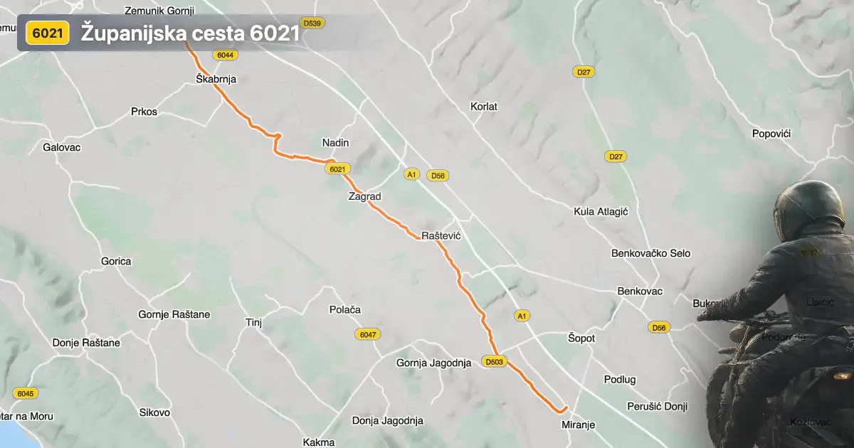
Županijska cesta 6021 is situated in the Dalmatian hinterland of Croatia, running between the settlements of Zemunik Gornji and Benkovac. The road traverses a region characterized by gentle hills and agricultural landscapes, providing a straightforward connection between these two communities. Zemunik Gornji, a village known for its proximity to Zadar Airport, marks the starting point, while Benkovac, a small town with historical significance, serves as the endpoint. The route is easily accessible from the wider Zadar region, making it a practical choice for riders seeking to explore inland Dalmatia. An interactive map showing the precise route of Županijska cesta 6021 can be found at the end of this article.
Loading road width, lane configuration, and surface quality dataOpen Map Explorer for More Road DetailsRoad Characteristics and Riding Experience
Županijska cesta 6021 extends for approximately 18.2 km (11.3 miles), with a road profile that is gently curved rather than sharply twisty. The surface is asphalt and is generally rated as excellent, offering a smooth and predictable ride for most of its length. The road is predominantly wide (about 75%), with some sections that are of medium width and a smaller proportion that are narrow. Most of the route features two lanes (about 58%), allowing for comfortable passing and steady traffic flow, while a minor portion is single-lane. The elevation ranges from 82 m (269 ft) to 168 m (551 ft), with gradual changes that do not present significant challenges in terms of steepness. The maximum speed limits along the route vary between 30, 40, and 50 km/h (19, 25, and 31 mph), reflecting the mix of inhabited and rural areas the road passes through.
Settlements and Points of Interest Along the Route
The road passes through several settlements, including Ulica Hrvatskog državnog sabora and Ulica 18. studenog 1991., before reaching Benkovac. Zemunik Gornji is notable for its rural character and proximity to Zadar Airport, making it a convenient starting point for travelers arriving by air. Benkovac, at the other end, is a town with a rich history, home to the Benkovac Castle and the popular Benkovac Fair, which attracts visitors from across the region. The route itself does not pass through major tourist attractions, but its location provides easy access to the broader attractions of Zadar County, including the Adriatic coast and the Vransko Lake Nature Park.
Road Closures, Seasonal Conditions, and Safety
There are no known restrictions or closures for motorcycles on Županijska cesta 6021. The road remains open throughout the year, as it is not subject to seasonal closures typical of higher-altitude or mountain routes in Croatia. However, riders should be aware of potential short-term closures or traffic controls due to local events or roadworks, which are usually announced in advance by local authorities. It is advisable to check the latest traffic updates on the official Croatian Automobile Club (HAK) website before setting out.
Tolls, Fees, and Additional Information
Županijska cesta 6021 does not currently require the payment of tolls or entrance fees for motorcycles or other vehicles. As with all public roads in Croatia, toll conditions may change in the future, so it is recommended to consult the Croatian Automobile Club (HAK) for the most up-to-date information regarding road charges and regulations. The road is maintained by local authorities and is generally in excellent condition, but riders should remain vigilant for occasional agricultural vehicles or local traffic, especially in inhabited areas.
| ROAD SCORE | ROAD ARTICLE |
|---|---|
7 | Adriatic Route - Jadranska Magistrala - Velebit Coastal Route |
6.6 | Exploring the D27 Mountain Pass: Motorcycling Across Velebit and the Zrmanja Valley |
| ROAD SCORE | ROAD ARTICLE |
|---|---|
8.7 | Riding the Poklon Pass: Exploring Županijska cesta 5047 through Učka Nature Park |
7 | Exploring the Rijeka–Gornje Jelenje Pass: A Motorcyclist’s Guide |
7 | Adriatic Route - Jadranska Magistrala - Velebit Coastal Route |