Exploring the Kozjak Pass: Kamnik–Ločica Route for Motorcyclists
Locals know best!
If you travel this road often or live close by you will be given a chance to provide your valuable rating soon! Sign in and stay connected.Location and Overview of the Kamnik–Ločica Road
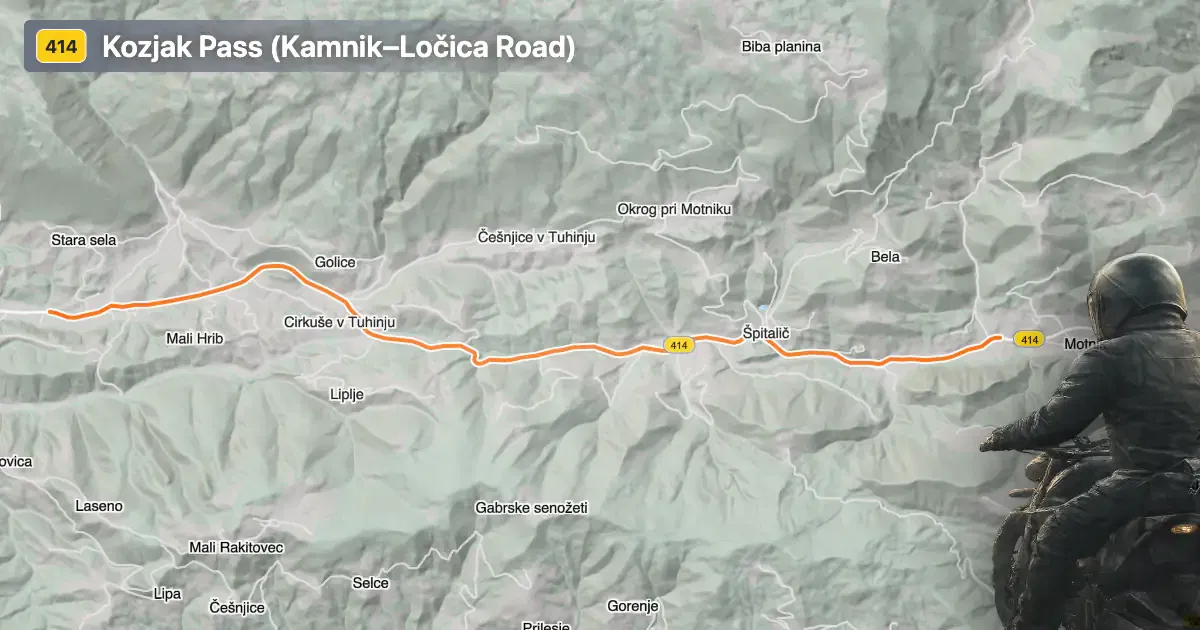
The Kamnik–Ločica road, officially designated as route 414, is situated in central Slovenia. It connects the village of Motnik at its western end to Laze v Tuhinju in the east, crossing the Kozjak Pass. The route lies within the eastern Alps, a region known for its varied terrain and moderate elevations. The road serves as a connector between the Kamnik and Ločica areas, providing access to local settlements and acting as a gateway to the Tuhinj Valley. An interactive map showing the precise alignment of the Kamnik–Ločica road can be found at the end of this article.
Loading road width, lane configuration, and surface quality dataOpen Map Explorer for More Road DetailsRoad Characteristics and Riding Experience
The Kamnik–Ločica road extends for approximately 10.2 km (6.3 miles), with the majority of its length featuring wide, two-lane asphalt. The surface quality is generally excellent, offering a smooth ride for most motorcycles. The route is not particularly twisty, with gentle curves dominating the alignment, making it suitable for riders seeking a relaxed mountain pass experience rather than a highly technical challenge. About 93% of the road is considered wide, with only a small portion (about 6%) classified as middle-width. The elevation ranges from 450 m (1,476 ft) at its lowest point to 671 m (2,201 ft) at the highest, with the Kozjak Pass itself reaching 658 m (2,159 ft). The road passes through inhabited areas for roughly a third of its length, providing occasional opportunities for rest or refueling in local villages.
Kozjak Pass and the Alpine Setting
The defining feature of this route is the crossing of the Kozjak Pass, a modest mountain pass within the Slovenian Alps. While not as high or as renowned as some of the major Alpine passes, Kozjak offers a distinct local character and serves as a practical link between valleys. The surrounding landscape is shaped by the eastern reaches of the Alps, with forested slopes and occasional clearings. The area is less frequented by international tourists, providing a quieter alternative to the busier mountain routes elsewhere in Slovenia. Riders may encounter local agricultural activity and traditional Slovenian rural architecture along the way.
Access, Closures, and Practical Considerations
The Kamnik–Ločica road is open to motorcycles and other vehicles throughout the year, with no regular seasonal closures reported. However, as with many mountain roads in Slovenia, temporary closures may occur due to maintenance work, adverse weather, or local events. Riders are advised to check local traffic updates before departure. There are no tolls or entrance fees currently required for motorcycles on this route, but toll conditions may change in the future. For up-to-date information on road tolls and regulations in Slovenia, consult the official DARS website.
Nearby Attractions and Points of Interest
While the Kamnik–Ločica road itself is primarily valued for its riding experience, the surrounding region offers several attractions worth exploring. The nearby town of Kamnik is known for its medieval old town and proximity to the Velika Planina alpine plateau, a popular destination for hiking and traditional herdsmen's huts. The Tuhinj Valley, accessible from the eastern end of the route, features thermal spas and rural landscapes. These sites provide opportunities for riders to extend their journey and experience the cultural and natural heritage of central Slovenia.
| ROAD SCORE | ROAD ARTICLE |
|---|---|
3.6 | Riding the Črnivec Pass: Kamnik to Gornji Grad by Motorcycle |
4.6 | Exploring the Litija–Zagorje ob Savi Road: A Motorcyclist’s Guide |
3.7 | Exploring the Trojane–Izlake–Trbovlje–Hrastnik–Šmarjeta Route: A Motorcyclist’s Guide Through the Slovenian Alps |
| ROAD SCORE | ROAD ARTICLE |
|---|---|
8 | Riding the Magnovec Pass: Ajdovščina to Lokve by Motorcycle |
7.4 | Riding the Podmeja Pass: Žalec to Trbovlje by Motorcycle |
7.4 | Strma Reber Pass: Motorcycling the 656 Kočevska Reka – Osilnica Road |