Exploring the Rogla–Zreče Alpine Route: A Motorcyclist’s Guide
Locals know best!
If you travel this road often or live close by you will be given a chance to provide your valuable rating soon! Sign in and stay connected.Location and Overview of the Rogla–Zreče Alpine Route
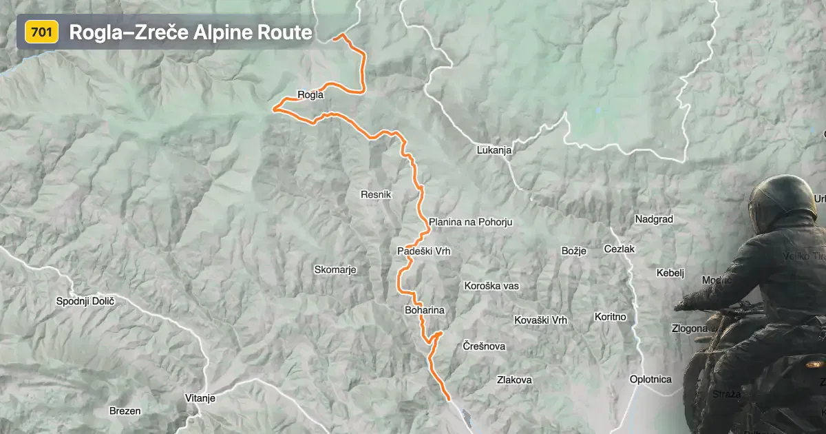
The Rogla–Zreče Alpine Route is situated in the northeastern part of Slovenia, within the Pohorje mountain range, a subrange of the Alps. The road connects the high-altitude resort area of Rogla with the town of Zreče, passing through settlements such as Resnik, Boharina, Padeški Vrh, Cesta na Roglo, and Loška Gora. The route is easily accessible from the town of Zreče, which lies approximately 1.4 km (0.9 miles) from the starting point. An interactive map showing the full extent of the route can be found at the end of this article.
Loading road width, lane configuration, and surface quality dataOpen Map Explorer for More Road DetailsRoad Characteristics and Riding Experience
The Rogla–Zreče Alpine Route covers a distance of approximately 18.5 km (11.5 miles), with an elevation range from 414 m (1,358 ft) to 1,496 m (4,908 ft). The road surface is asphalt and is generally rated as very good, providing a comfortable and predictable riding experience. Most of the route consists of two lanes (about 90%), with the majority of the road being wide (about 90%), allowing for safe overtaking and smooth navigation through curves. The road is moderately curvy, offering a balance between straight sections and gently winding segments, making it suitable for riders of varying skill levels. Approximately 22% of the route passes through inhabited areas, while the remainder traverses forested and mountainous terrain. The road runs adjacent to the Dravinja River for a short section, adding to the variety of landscapes encountered along the way.
Attractions and Points of Interest Along the Route
The route is notable for its proximity to several local attractions. Rogla is a well-known ski and wellness resort, offering year-round activities such as hiking, mountain biking, and spa treatments. The town of Zreče is recognized for its thermal spa facilities, making it a popular destination for relaxation after a day’s ride. Along the way, riders can explore the natural beauty of the Pohorje Mountains, which are part of the larger Alps. The Dravinja River, which the road briefly follows, is a feature of the local landscape and can be further explored via the Dravinja entry. For those interested in local culture, the settlements of Resnik and Loška Gora offer a glimpse into rural Slovenian life. More information about the region can be found on Lonely Planet.
Seasonal Closures and Road Access
The Rogla–Zreče Alpine Route is generally open to motorcycles throughout the year. However, due to its elevation and exposure to alpine weather conditions, temporary closures can occur during the winter months, particularly after heavy snowfall or during periods of maintenance. Riders are advised to check local traffic updates before planning a trip, especially in late autumn and early spring when weather conditions can be unpredictable. There are no known event-related closures affecting this route on a regular basis.
Tolls, Fees, and Practical Information
Currently, there are no tolls or entrance fees required to ride the Rogla–Zreče Alpine Route. Riders should be aware that toll conditions may change in the future, and it is advisable to consult official resources for the most up-to-date information. For details on road tolls and vignettes in Slovenia, visit the official DARS website. Standard speed limits apply, with rural roads typically limited to 90 km/h (56 mph) unless otherwise posted. Riders should exercise caution in inhabited areas and during adverse weather conditions.
| ROAD SCORE | ROAD ARTICLE |
|---|---|
4.5 | Exploring the 704 Radlje–Ribnica–Brezno Route: A Motorcyclist’s Guide Through the Slovenian Alps |
4.7 | Exploring the Šentjur–Slovenske Konjice Alpine Route by Motorcycle |
3.6 | Exploring the Slovenska Bistrica–Slovenske Konjice Mountain Route: A Motorcyclist’s Guide |
| ROAD SCORE | ROAD ARTICLE |
|---|---|
8 | Riding the Magnovec Pass: Ajdovščina to Lokve by Motorcycle |
7.4 | Riding the Podmeja Pass: Žalec to Trbovlje by Motorcycle |
7.4 | Strma Reber Pass: Motorcycling the 656 Kočevska Reka – Osilnica Road |