Exploring the Železniki–Sorica Road: A Technical Overview for Motorcyclists
Locals know best!
If you travel this road often or live close by you will be given a chance to provide your valuable rating soon! Sign in and stay connected.Location and Access
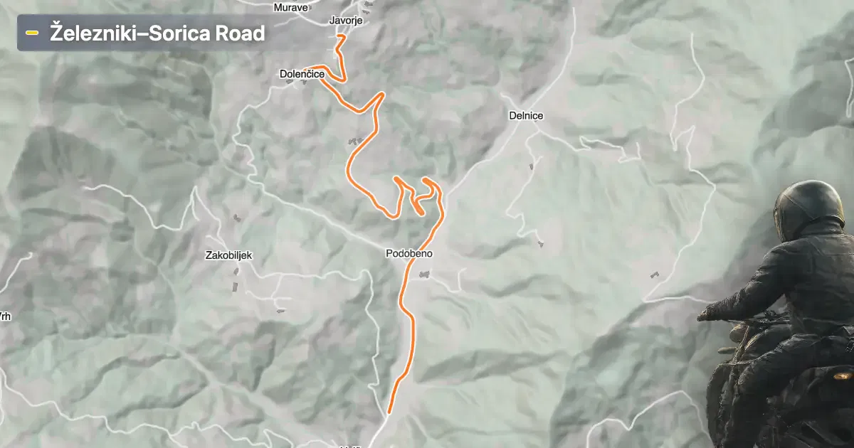
The Železniki–Sorica road is situated in the Upper Carniola region of Slovenia, connecting the town of Železniki with the surrounding rural areas. The route begins near Železniki, a town recognized for its historical ironworks and proximity to the Julian Alps. The road traverses a varied landscape, offering access to both inhabited and remote sections of the region. An interactive map showing the precise route of the Železniki–Sorica road can be found at the end of this article.
Loading road width, lane configuration, and surface quality dataOpen Map Explorer for More Road DetailsRoad Characteristics and Technical Details
The Železniki–Sorica road extends for approximately 5.05 km (3.14 miles), with an elevation range from 410 m (1,345 ft) to 711 m (2,333 ft). The road is predominantly surfaced with high-quality asphalt, rated as excellent by local standards. Riders will encounter a mix of gently curved and moderately twisty sections, making it suitable for both experienced and less experienced motorcyclists. The road width varies, with about 53% of the route classified as medium width and 33% as wide, ensuring comfortable passage for motorcycles and other vehicles. The number of lanes alternates between one and two, with two-lane sections comprising nearly half of the route (about 47%). Approximately 29% of the road passes through inhabited areas, providing occasional access to local amenities.
Surface Quality and Riding Experience
Motorcyclists will appreciate the consistently smooth asphalt surface, which is maintained to a high standard. The road's gentle to moderate curves allow for a relaxed riding pace, while the elevation changes provide a sense of progression without presenting significant technical challenges. The combination of wide and medium-width sections ensures that overtaking is generally safe, and the presence of inhabited areas offers opportunities for rest stops. The road is suitable for a variety of motorcycle types, including touring and sport-touring models.
Seasonal Accessibility, Closures, and Fees
The Železniki–Sorica road is open to motorcycles throughout the year, with no regular seasonal closures reported. However, riders should be aware that winter conditions in the Upper Carniola region can lead to temporary closures or hazardous surfaces due to snow and ice. There are no tolls or entrance fees currently required for motorcycles on this route. Riders are advised to verify the latest road conditions and toll information through the official DARS website, as toll policies may change in the future.
Nearby Attractions and Points of Interest
While the Železniki–Sorica road itself is primarily a transit route, the nearby town of Železniki offers historical and cultural attractions, including the Ironworks Museum of Železniki. The region is also known for its proximity to the Julian Alps, which provide additional opportunities for exploration and outdoor activities. Motorcyclists seeking to extend their journey can consider routes leading towards the village of Sorica or further into the alpine landscape.
| ROAD SCORE | ROAD ARTICLE |
|---|---|
4.4 | Riding the Kladje Pass: Žiri to Straža Mountain Road |
4.7 | Exploring the 407 Gorenja vas – Vrhnika Route: A Motorcyclist’s Guide Through Polhograjsko Hribovje |
| ROAD SCORE | ROAD ARTICLE |
|---|---|
8 | Riding the Magnovec Pass: Ajdovščina to Lokve by Motorcycle |
7.4 | Riding the Podmeja Pass: Žalec to Trbovlje by Motorcycle |
7.4 | Strma Reber Pass: Motorcycling the 656 Kočevska Reka – Osilnica Road |