Exploring the 661 Krmačinai–Metlika Road: A Motorcyclist’s Guide
Locals know best!
If you travel this road often or live close by you will be given a chance to provide your valuable rating soon! Sign in and stay connected.Location and Regional Context
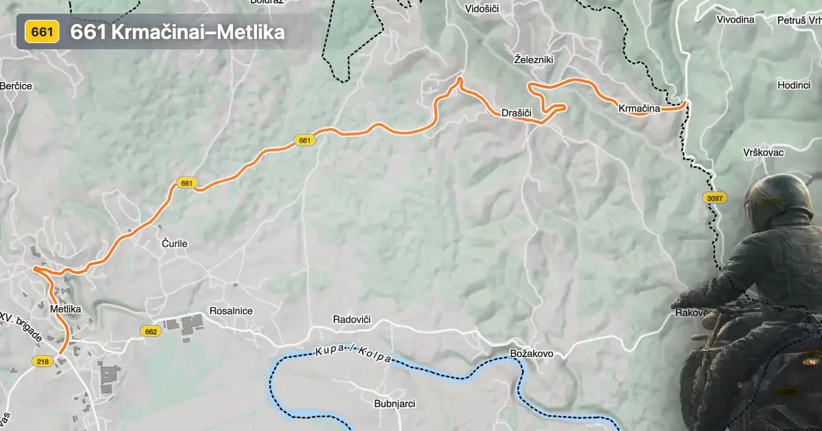
The 661 Krmačinai–Metlika road is situated in the southeastern part of Slovenia, within the Bela Krajina region. The route links the settlements of Drašiči, Cesta bratstva in enotnosti, and Vinogradniška cesta, ultimately connecting to the town of Metlika. This area is characterized by rolling hills, vineyards, and a rich cultural heritage. Metlika, the nearest major town, serves as a gateway to the region and is known for its historic old town and proximity to the Kolpa River. An interactive map showing the precise route of the 661 Krmačinai–Metlika road can be found at the end of this article.
Loading road width, lane configuration, and surface quality dataOpen Map Explorer for More Road DetailsRoad Characteristics and Riding Experience
The 661 Krmačinai–Metlika road extends for approximately 9.3 km (5.8 miles), offering a ride that is gently curved rather than highly twisty. The asphalt surface is of high quality, providing a smooth and reliable riding experience. The road maintains two lanes throughout its length (about 100%), with the width varying from narrow to wide, though the majority of the route is considered wide (about 46%). Riders will encounter a mix of open countryside and inhabited areas, with roughly one-third of the road passing through settlements. Elevation ranges from 154 m (505 ft) to 262 m (860 ft), resulting in mild elevation changes suitable for riders of all experience levels. The maximum speed limit is 50 km/h (31 mph), reflecting the road’s passage through populated areas and its regional character.
Points of Interest Along the Route
While the 661 Krmačinai–Metlika road itself is primarily a connector between local settlements, it provides access to several attractions unique to the Bela Krajina region. Metlika is notable for its Metlika Castle, which houses the Bela Krajina Museum and offers insights into the area’s history and traditions. The nearby Kolpa River is a popular destination for outdoor activities such as swimming, kayaking, and fishing. The region is also known for its vineyards and traditional white houses, which can be observed along the route, especially near Drašiči, a settlement recognized for its wine cellars and annual wine festivals. For those interested in local culture, the Bela Krajina Museum in Metlika provides further context on the area’s customs and heritage.
Road Closures, Seasonal Considerations, and Regulations
There are no known permanent closures for motorcycles on the 661 Krmačinai–Metlika road. The route remains open year-round, as the region’s mild climate and low elevation do not typically necessitate winter closures. However, temporary closures may occur due to local events, maintenance, or adverse weather conditions. Riders are advised to check local traffic updates or the Slovenian Traffic Information Center for the latest information before planning their journey. Standard Slovenian traffic regulations apply, including adherence to posted speed limits and the use of appropriate safety gear.
Tolls, Fees, and Practical Information
The 661 Krmačinai–Metlika road does not currently require a toll or entrance fee for motorcycles or other vehicles. Riders should note that toll conditions may change in the future, and it is advisable to consult official resources for the most up-to-date information. For comprehensive details on road tolls and vignettes in Slovenia, refer to the DARS vignette information page. Fuel stations and basic amenities are available in Metlika, making it a convenient starting or ending point for the journey.
| ROAD SCORE | ROAD ARTICLE |
|---|---|
5.2 | Exploring the Novo mesto – Metlika Route: A Motorcyclist’s Guide |
4.3 | Exploring the Metlika–Božakovo Road: A Motorcyclist’s Guide Along the Kupa River |
4.4 | Exploring the Žumberak–Samobor Hills Route: A Motorcyclist’s Guide through Park prirode Žumberak – Samoborsko gorje |
| ROAD SCORE | ROAD ARTICLE |
|---|---|
8 | Riding the Magnovec Pass: Ajdovščina to Lokve by Motorcycle |
7.4 | Riding the Podmeja Pass: Žalec to Trbovlje by Motorcycle |
7.4 | Strma Reber Pass: Motorcycling the 656 Kočevska Reka – Osilnica Road |