Exploring the Žumberak–Samobor Hills Route: A Motorcyclist’s Guide through Park prirode Žumberak – Samoborsko gorje
Locals know best!
If you travel this road often or live close by you will be given a chance to provide your valuable rating soon! Sign in and stay connected.Location and Access
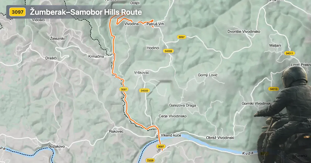
Županijska cesta 3097 is located in southeastern Slovenia, running close to the border with Croatia. The road traverses the protected area of Park prirode Žumberak – Samoborsko gorje, a region known for its rolling hills, dense forests, and rural landscapes. The nearest major settlements are Ozalj, approximately 6.6 km (4.1 miles) from the starting point, and Metlika, about 7.3 km (4.5 miles) from the endpoint. The road’s proximity to these towns makes it accessible for riders coming from either Slovenia or Croatia. An interactive map showing the route can be found at the end of this article.
Loading road width, lane configuration, and surface quality dataOpen Map Explorer for More Road DetailsRoad Characteristics and Riding Experience
The Žumberak–Samobor Hills Route extends for 6.5 km (4 miles), with an elevation range from 126 m (413 ft) to 346 m (1,135 ft). The road is predominantly surfaced with asphalt of good quality, providing a comfortable ride for most motorcycles. Riders will encounter a moderately twisty alignment, offering a balance between technical curves and more relaxed stretches. The majority of the route features a middle-width carriageway (about 59%), with sections that are narrow (14%) and some that are wide (25%). Most of the road is single-lane (78%), with the remainder accommodating two lanes (22%). Approximately 21% of the route passes through inhabited areas, while the rest winds through natural landscapes, offering a sense of seclusion and immersion in the park’s environment.
Natural Attractions and Points of Interest
Park prirode Žumberak – Samoborsko gorje is the defining feature of this route. The park is recognized for its biodiversity, traditional rural settlements, and opportunities for outdoor activities. Motorcyclists may wish to pause and explore the park’s hiking trails or visit local villages that reflect the cultural heritage of the region. The nearby town of Ozalj is notable for its historic castle and riverside setting, while Metlika offers a glimpse into the traditions of southeastern Slovenia. The route’s passage through the park ensures that riders are surrounded by natural beauty and have access to several points of interest along the way.
Seasonal Closures and Regulations
There are currently no permanent closures for motorcycles on Županijska cesta 3097. However, as the road passes through a protected natural area, temporary restrictions may be imposed due to weather conditions, maintenance, or park-related events. Winter closures are possible, especially in periods of heavy snowfall or adverse weather, as is common in hilly regions. Riders are advised to check local sources or the official Park prirode Žumberak – Samoborsko gorje website for up-to-date information on road accessibility before planning their journey.
Tolls, Fees, and Further Information
At present, there are no tolls or entrance fees specifically for using Županijska cesta 3097. Access to Park prirode Žumberak – Samoborsko gorje is generally free for transit, but certain activities or facilities within the park may require payment. Riders should be aware that toll conditions may change in the future, and it is recommended to consult the Slovenian government transport portal for the latest information on road tolls and entrance fees in Slovenia.
| ROAD SCORE | ROAD ARTICLE |
|---|---|
4.9 | Exploring the 661 Krmačinai–Metlika Road: A Motorcyclist’s Guide |
4.3 | Exploring the Metlika–Božakovo Road: A Motorcyclist’s Guide Along the Kupa River |
| ROAD SCORE | ROAD ARTICLE |
|---|---|
8 | Riding the Magnovec Pass: Ajdovščina to Lokve by Motorcycle |
7.4 | Riding the Podmeja Pass: Žalec to Trbovlje by Motorcycle |
7.4 | Strma Reber Pass: Motorcycling the 656 Kočevska Reka – Osilnica Road |