Exploring the Hengstpassstraße: A Mountain Pass Route through Austria’s Kalkalpen National Park
Locals know best!
If you travel this road often or live close by you will be given a chance to provide your valuable rating soon! Sign in and stay connected.Location and Geographic Context
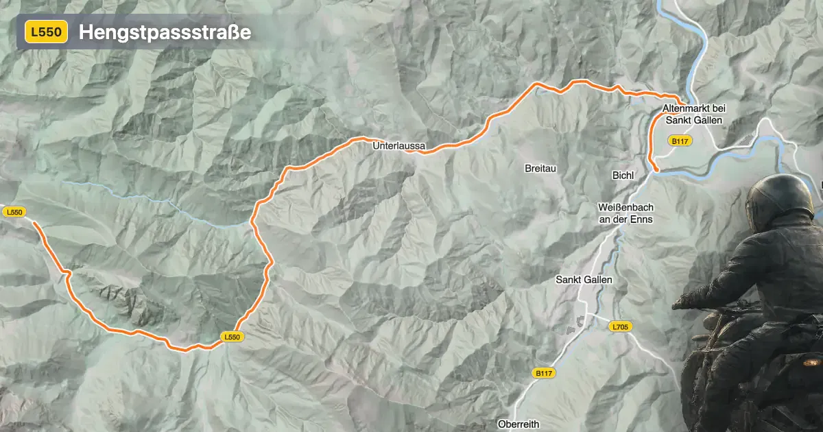
The Hengstpassstraße is situated in Upper Austria, connecting the regions of the Oberösterreichisches Ennstal and Steirisches Ennstal valleys. The road crosses the Hengstpass at an elevation of 985 m (3,232 ft), providing a direct route through the Haller Mauern and Ennstaler Alpen mountain ranges. The route also skirts the Kalkalpen National Park, a UNESCO World Heritage site known for its extensive forests and diverse wildlife. The Enns River runs adjacent to a portion of the road, adding to the varied alpine scenery. An interactive map showing the Hengstpassstraße can be found at the end of this article.
Loading road width, lane configuration, and surface quality dataOpen Map Explorer for More Road DetailsRoad Characteristics and Riding Experience
The Hengstpassstraße extends for approximately 22.3 km (13.9 miles), with the majority of the route featuring two wide lanes (about 90%) and a high-quality asphalt surface. The road is gently curved, making it suitable for riders seeking a relaxed yet engaging journey through the mountains. Elevation ranges from 413 m (1,355 ft) at its lowest point to 1,003 m (3,291 ft) at its highest, with the Hengstpass itself marking a significant summit. The route passes through both inhabited and remote areas, with roughly 40% of the road traversing settlements. Speed limits vary along the route, with sections posted at 100 km/h (62 mph), 70 km/h (43 mph), 50 km/h (31 mph), and 30 km/h (19 mph), depending on proximity to towns and road conditions.
Natural Attractions and Points of Interest
Riders on the Hengstpassstraße will encounter several viewpoints offering expansive vistas of the surrounding Alps. The road’s proximity to the Kalkalpen National Park provides opportunities to observe the region’s unique flora and fauna. The Enns River, which the road follows for a portion of its length, is a significant tributary of the Danube and a defining feature of the local landscape. The valleys of Oberösterreichisches Ennstal and Steirisches Ennstal frame the route, while the Haller Mauern and Ennstaler Alpen mountain ranges provide a dramatic alpine backdrop. For those interested in geology and alpine ecosystems, the area is also notable for its karst formations and dense forests.
Seasonal Accessibility and Road Regulations
The Hengstpassstraße is generally open to motorcyclists throughout the year, but winter conditions can lead to temporary closures due to snow and ice, particularly at higher elevations. Riders are advised to check local traffic reports and weather forecasts before planning a journey, especially during the colder months. There are no permanent restrictions on motorcycle access, but occasional closures may occur for maintenance or special events. For up-to-date information on road conditions and closures, consult the ASFINAG Traffic Reports.
Tolls, Fees, and Practical Information
Currently, there is no toll or entrance fee required to ride the Hengstpassstraße. However, toll conditions may change in the future, and it is advisable to verify the latest information before your trip. For comprehensive details on road tolls and fees in Austria, visit the ASFINAG Toll Information page. The road’s excellent surface quality and wide lanes make it accessible for a range of motorcycles, from touring bikes to sport models. Facilities such as fuel stations and rest areas are available in nearby settlements, though services may be limited in more remote sections.
| ROAD SCORE | ROAD ARTICLE |
|---|---|
4 | Exploring the Hochschwab Straße – Lawinenschutztunnel Hesslahn: A Motorcyclist’s Guide |
4.2 | Exploring the Radstatthöhe Pass: B 25 Erlauftal Straße in Austria |
4.7 | Riding the Pyhrn Pass: Spital am Pyhrn to Liezen |
| ROAD SCORE | ROAD ARTICLE |
|---|---|
9 | Silvretta High Alpine Road (Silvretta-Hochalpenstraße (Bielerhöhe)): A Premier Alpine Motorcycle Route in Austria |
5.8 | Loibl Pass (Loiblpass): A Technical Overview for Motorcyclists Crossing the Karavanke |
4.2 | Ötztal Glacier Road (Ötztaler Gletscherstraße): A Technical Overview for Motorcyclists |